Greetings, and welcome to the August 2009 Sampler.
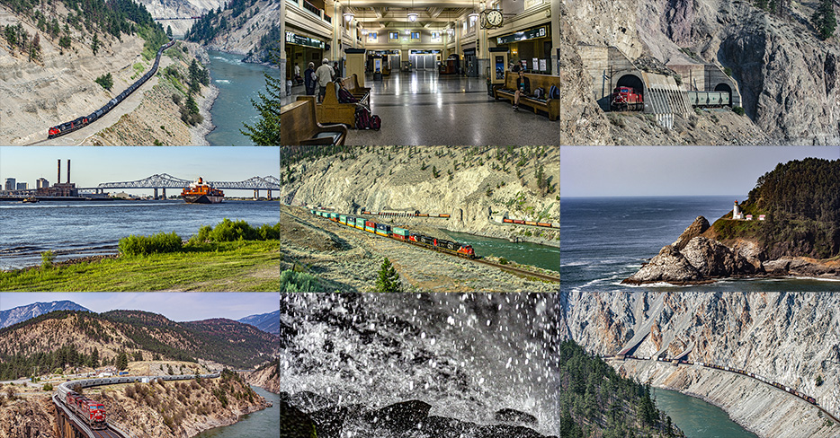
Most of the images that you will see in this piece are components of my very intense summer of 2009, samples of the images of which can be seen in the June 2009 Sampler and July 2009 Sampler essays, and this August 2009 essay picks up right where the July 2009 essay stopped, on a descent from Yellowhead Pass that is a metaphor to my own life.
Descending From On High
There are plenty of metaphors of this trip to my life, of being at a high mountain pass in the heat and then coming down, especially given what would happen on one of the last stops on my journey before I went home, and being able to maintain glory for only so long.
As you know from the July 2009 Sampler essay, in the month of July 2009, my passport got more use than it ever got (and is ever likely again to get), and my camera got a very high amount of use along with it.
On the afternoon of July 31st, we descended Yellowhead Pass for the final time, and, although I could not see it at the time, it was as if I was also descending from the high point of hope in my life, even though I probably could and should say the same thing about another actual mountain-pass descent that I made five months later, but we’ll get to that soon enough.
We spent the night of the 31st in Kamloops, a city that I really wish that I could know better. Kamloops is where the Canadian Pacific Railway mainline from Calgary converges with the Canadian National Railway mainline from Edmonton via Jasper and Yellowhead Pass. Secondary lines notwithstanding, Kamloops is the first place that the two transcontinental mainlines of Canada’s two major railroads converge since they intersect at Winnipeg.
The CP mainline approaches Kamloops from the east, while the CN mainline approaches the city from the north, after turning south west of Yellowhead Pass. From there, both railroads follow the same series of river valleys and banks – the Thompson River, then the Fraser River – for hundreds of miles into Vancouver.
We went eastward on the CP and found, among many other things, a westbound grain train, seen here at Notch Hill.
We didn’t photograph many trains on this day. We did stop at the site of the “Last Spike” to complete the Canadian Pacific Railway.
I think that we spent the night in Kamloops again, at the same hotel, and this might have been the night that I walked to McDonald’s in the middle of the night.
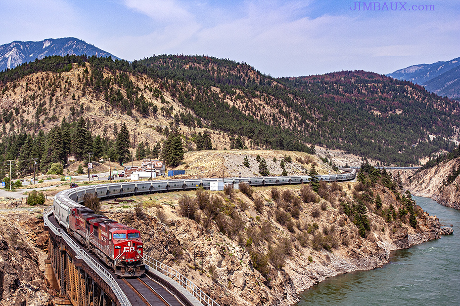
The next day, the 2nd, we were in the Thompson River Canyon, a fascinating place indeed, and one that I would like to visit again.
While there, I got one of the most memorable sets of images that I have ever made, less so because of the image quality and more so because of the stories told in that image, but, even moreso, what my interest in that story says about me and what people know as my interests and strengths.
This was the scene on this day in 2009 at the Skoonka Tunnels along the Thompson River Canyon in Spences Bridge, British Columbia. There is so much to be ‘seen’ in this image, so much of the history of not just Canada but also North America, and so much more than just history, as much of what can be perceived here are stories of modern-day economics and geopolitics, with also geology, topography, physics, and engineering to be seen here.
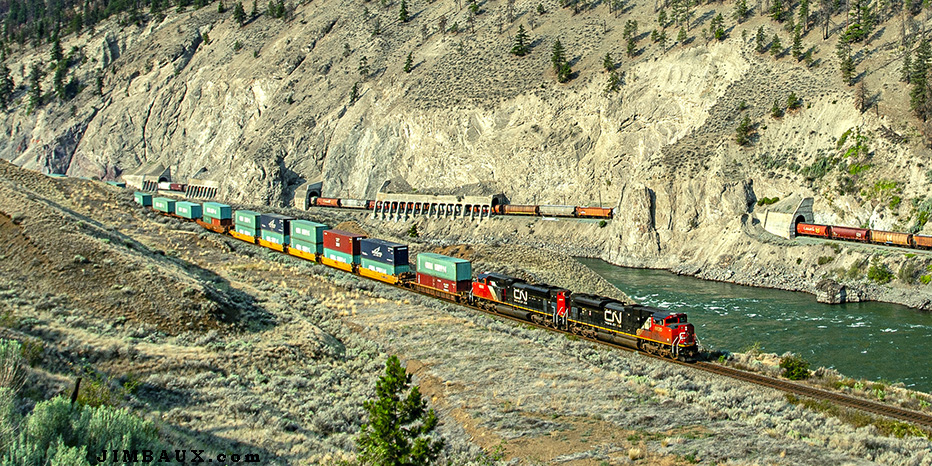
As you might have ascertained from my pictures and writings, I attempt to perceive things from the confluence of various professional disciplines, as opposed to just one or two disciplines, with the possibility of it being appropriately shaded under an umbrella of art.
On a most literal level, we see two trains in the above image, each traveling in an opposite direction. In the distance, we see Canadian National Railway train A417-51 moving west on CN rails, and, in the foreground, we see a CN intermodal train – probably the Q106 – moving east on rails of its competitor, the Canadian Pacific Railway, the only other major, transcontinental railway in Canada.
West of Kamloops, British Columbia, down the Thompson River (seen here) and then the iconic Fraser River (into which the Thompson River empties), the two railroads follow a roughly parallel (to each other) routing through the mountainous terrain all the way to the Pacific Coast at Vancouver. For the most steep and mountainous part of their respective routings, including the section seen here, the two competing railroads in the 1990s agreed between themselves (as far as I know, without any government or customer intervention or prodding) to implement a “directional running” arrangement, in which all westbound trains of both railroads would use one railroad’s line and all eastbound trains of both railroads would use the other railroad’s line.
The reasons for this arrangement have as much to do with topography, which is natural, as they do with the man-made economics of increasing global trade, particularly with the Far East, the origin of most of the containers (see the CHINA SHIPPING container) in the intermodal train in the foreground, and advances in railroad technology; the fact that the Canadian National Railway had gone from being a government-run railroad to a successful privately-run railroad a few years earlier may have also been a factor.
First, topography:
Normally, when railroads need to add capacity, they simply add new tracks both in the form of newer and longer sidings and in the form of additional mainlines, like double-tracking a line that was previously single-track. That option was hardly available in the mountainous terrain in which the roadbed of the existing single track mainline itself had to be blasted off of the cliff itself (particularly in CN’s case.) Even with CP’s less rocky mainline, the complications of running heavy trains up and down steep grades becomes exacerbated when they have to stop and take sidings to meet trains coming in the opposite direction. So, the directional running, which essentially means that trains need to stop only to change crews, greatly decreases the wear on brakes, the potential for disastrous runaways, and the expenditure of great amounts of energy to accelerate trains up grades from stops.
Second, economics and railroad technology:
As global trade increased, so too did the international business done by the railroads, including that seen in the above picture, particularly in the intermodal train. Technology including distributed power and better means of braking allowed train-lengths to grow to a normal length of almost two miles. Finding space to build sidings that length in the mountains is difficult if not impossible. Also, plenty of iron ore and coal bound for Japan and plenty of automobiles coming from Japan pass through here.
Without me even telling you which railroad was which, as I did in the second paragraph below the image, a knowledge of the history of these lines could help you easily tell which one of the lines in the picture was CP and which one was CN.
When the Canadian Pacific Railway built its mainline through here in the 1880s, it picked the easier side of the rivers (both the Thompson River and then the Fraser River after their confluence downriver from here in Lytton) on which to build its track. Three decades later, when what would become the Canadian National Railway built its line through here, the CP already had the easier side of the rivers, and the builders of the second line, with new technology that did not exist in the 1880s, blasted away the more steep side of the river to build the mainline that you see partially tunneled in the background. As one might expect, though, the “easier side of the river” changes depends where one is along the length of a river. Consequently, the two lines cross the rivers – and, therefore, each other – a few times along the parallel routing.
I mentioned, too, that some US history and economics can be seen in this image. Some of the traffic that passes east through here enters the United States; most of the cross-border CP traffic enters in North Dakota on the former Soo Line railroad going to Minneapolis, and much of the cross-border CN traffic enters the United States on CN rails south of Winnipeg.
CN train A417, seen in the background going through the Skoonka Tunnels, is a regional manifest train from Edmonton, Alberta, to Vancouver, BC. Though not seen in this image, the train included some auto-rack cars, likely empty and likely bound for loading of Japanese automobiles in Vancouver.
Also, though, given the sometimes unpleasant reality (for lack of a better term) that Canadian identity is often defined, as Canadian-American journalist Peter Jennings said, by negation, that being Canadian means that you’re not British and not American, it’s important to note the iconic role of the Canadian Pacific Railway in Canada’s history and national identity. The admission of British Columbia into the Canadian confederation – and, thus, making Canada a coast-to-coast nation like the United States – was contingent on the completion of the railroad, and CP leaders during its construction were under pressure from the new nation’s parliament to build the line close to the US border, primarily to prevent encroachment from the south by American railroads, despite the fact the CP’s more southern route was more mountainous. East of the location shown in this picture, CN’s mainline takes a more northerly route through Yellowhead Pass.
The fascinating history is alive as these railroads remain vital to the economies of both the United States and Canada today, moving many of the products that you use. Here, you see more than the Skoonka Tunnels and the river; here, you see how the products get to you!
Anyway, I don’t know where we slept that night, but it must have been around Lytton.
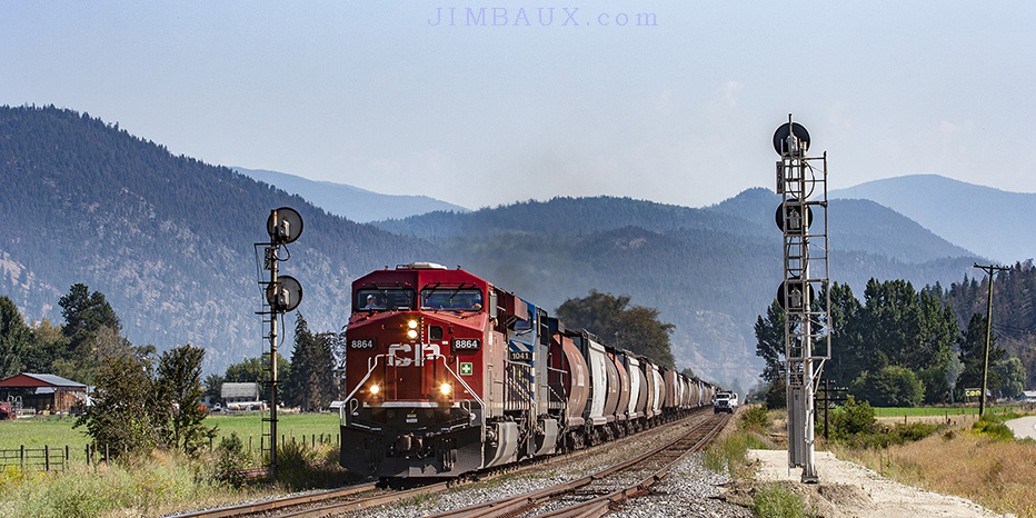
That is where, the next day, the 3rd, we caught this westbound CP potash train crossing the end of the Thompson River.
The track here rejoins the eastern bank of the rivers, meaning that both railroads are on the same side of the river for a little while here.
Three hours later, we were in Boston Bar, where we got our last real action shots of this trip. After that, it was a really long drive back down to sea level.
We spent the night in Port Coquitlam. I am fairly sure that we got there no earlier than dusk; there was no time or energy to explore the town, even though I wanted to do so. The hotel seemed like an actual hotel.
The next morning, the 4th, Bob dropped me off at a bus station on his way to the airport. Our two-man western-Canada trip was now done, with plenty of good pictures, memories, experience, and education, and way too much fast food, mainly A&W.
I got onto the bus, after doing the passport check, but I remember getting out of the bus – and having to ask to get out of the bus – while waiting for its departure because the lack of air circulation inside of that bus was bothering me, and I was getting sweaty.
This was a sign of a problem – or a problem itself – of which I had long known but tried to not discuss due to its implications. More recently, I think that it is a function of either autism or whatever neurological problem from which autism stems.
Once it was time for the bus to leave, I reboarded. I have basically no memory of the bus ride to Seattle, but that is where our picture for the day is, at the King Street Station.
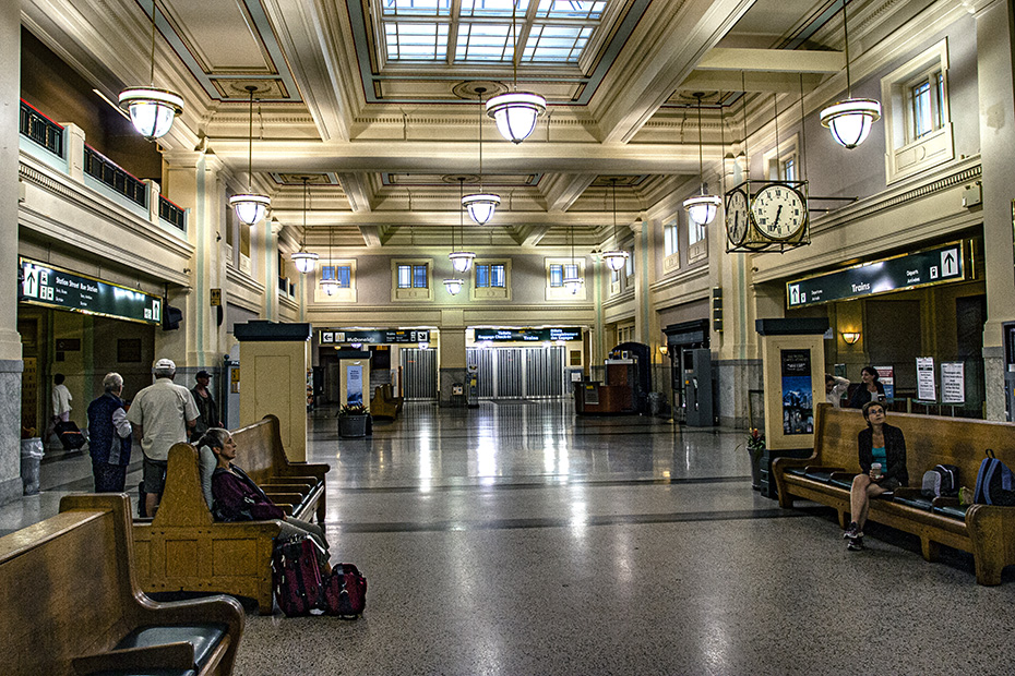
I had a little bit of time before I had to board the train to Oregon. So, I walked around the neighborhood and visited Occidental Park and a Starbucks.
I remember a few things about the train ride, both of which involved the fact that I had my scanner with me and on.
A young guy sat across from me, seemingly somewhat eager to make conversation, and I remember hearing “diverging clear” over the radio; I said that we were about to switch over to a different track, and, when we indeed did, he seemed rather amazed. It’s kind of sad that that is all that I remember from that conversation with him.
The other thing from this ride that I remember has, although I have recalled it only as I sat down to write this essay, taken on greater meaning now that I think about it a decade after it happened (which is when this is being written.) There was this really smokin’-hot young female conductor working on this train. I can’t remember how the conversation started or who started it, but it may have started when she or her male coworker saw my scanner.
I am always a slight bit reluctant to advertise to railroad employees, whether freight railroads or a more consumer-driven Amtrak, to advertise that I have a scanner, for fear that they might be put off that I am listening in on their conversations.
Not only did she ask me in a totally-not-unfriendly way if I was a “foamer” (yes, she used that word), but she said that she was surprised to see that someone who looked like I did was a foamer, which I took as a huge compliment and, perhaps more pertinently, a sign that I was doing something right.
A decade later, though, I have what I think is a more accurate and realistic and less benign view of what that incident meant.
It meant that I had masked well.
Yes, it’s good that I had maintained an active lifestyle and exercised and lifted weights, which was both healthy for me and made me appear ‘normal’ to the outside world, and, yes, it’s good that I knew how to behave in public so as to not offend anyone, but there has also been plenty of internal damage done to the self from masking, and, within a few years, my ability to continue masking eroded, with some bad consequences.
If this violent society did not require conformity and compliance at the threat of destitution (which is why we must mask), perhaps folks like me – and everyone else – could have a decent, secure life; my land-owning, subsistence-farming great-grandfathers, one of whom I suspect was on the autism spectrum, did not have to deal with this threat.
So, perhaps seemingly paradoxically, it’s only once I encountered a community of similarly-wired individuals who have experienced similar suffering that I could assert that I am not the problem while allowing me to admit that I indeed have one.
Masking is absolutely exhausting, and I cannot do it anymore.
Anyway, later that afternoon, I arrived at Corvallis. Lisa met me at the train station, but I don’t remember that, either.
The next day, the 5th, Lisa took me to the coast, something that I found to be amazing. With my camera, she took a “Baywatch” picture of me.
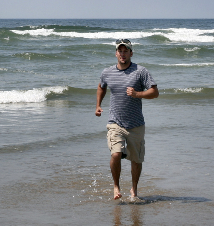
I would soon start my last good year as a school teacher, and I was able to use the experience to teach my geography students about how differing ocean currents mean that the water here and the water at the same latitude on the East Coast have very different temperatures! It was cold!
So, we went south along the coast, and we saw Heceta Head, and, now, here is one photograph that I took on this day.
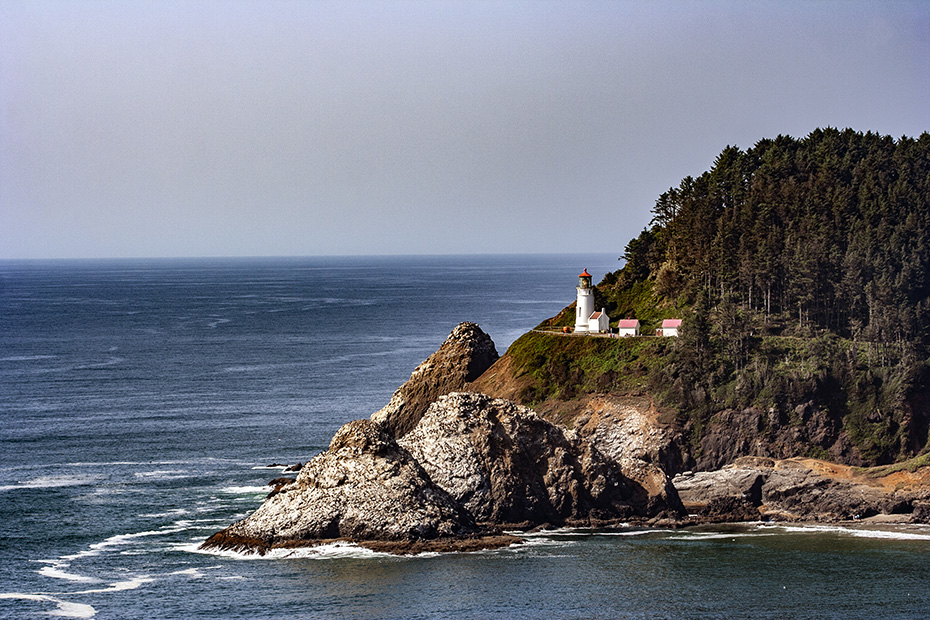
I love Oregon. I really do. Were it not for the fact that, any time now, the coastal part of the state will suffer the worst natural disaster in the history of the United States of America, it would be at the top of my list of potential places to which to relocate.
The next day, the 6th, was the first sign of something that would become a much bigger problem for me three-and-a-half years later.
We went to Silver Falls State Park, a really neat place.
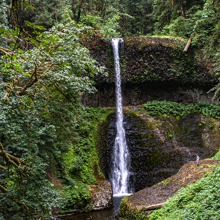
The hike through the park was, well, a hike. The problem for me was that, although the hike was relatively short in length, it plenty of steepness to it.
I can’t remember when I began to have trouble walking. It may have been later that night, or it might not have happened until the next morning, but, although I wasn’t in terrible pain, I became quite immobile. I was glad that this had been my last stop in this intense summer of travel, but now I was worried about how I would perform at the day job next week once I returned.
I was hunched over. Apparently, I had herniated a disc in my lower back, but I didn’t become familiar with that terminology until later.
The next day, the 7th, we didn’t do much, because I couldn’t do much.
Corvallis is neat. I guess that Lisa got caught up on personal tasks, because all that I could do was mope around. I suppose that I played with the cats some.
I was quite embarrassed by the fact that a woman almost old enough to be my mother was able to outdo me on that hiking trail.
The next day, Saturday the 8th, it was time to finally go home, and, apparently, I was feeling slightly better, just because I don’t recall being so limited that day. I had been worried about boarding an airplane feeling like I was with an injured back. However, five years to the day later, I was awaiting my second of three back surgeries of 2014 when I made some pictures of railroad activity in New Orleans.
I must not have been feeling as bad as I had been the day before, because I was able to get to the farmers market at Corvallis with Lisa.
Later, Lisa took me to PDX for my air journey back to New Orleans via DFW. Mr. T. (I think) picked me up at MSY, and, gosh, when we walked out of the baggage claim area to get to his automobile, I experienced that tired and true experience of a Louisiana person returning home by air in the summer after being in much cooler and drier areas; I felt the humidity wrap itself around me.
That Monday, it was back to work at the school for what would be my last really good school year as a school teacher.
I think that I had peaked the year before, though, and I could tell that something was not right inside, but, in terms of my actual performance for that school year, it was not noticeably worse than the year before.
Like I said, though, that descent from Yellowhead Pass on the last day of July followed a week later by injuring my back was a real metaphorical sign of what was happening in my life then. It’s as if I was made for life prior to then.
Wait, there are actually two more pictures from the month of August 2009. On the 24th, my roommate from my time at ITESM five years before was in town, in New Orleans. I was super-busy with the job and occasionally processing images from my intense summer, and trying to have a somewhat normal life with going to the gym and working at a job that had plenty of take-home work, but I totally had to not only stop what I was doing but also take the camera out for this.
Michael and his girlfriend were staying in the French Quarter and without an automobile. They were not familiar with the metro area, and I think that Michael had never been here. Having an automobile, I do what I usually do when there are people I know visiting from out of town: I get them out of the French Quarter.
I took them on a trip across the river where they could see a good view of the city, and that’s where, I took my camera out for the first time since being in Oregon.
This was after I had taken a picture of them sitting on the levee, the real reason that I had taken the camera out.
We then went along to the Huey P. Long Bridge, something that I think is an engineering marvel, and cross the river back there. Afterward, we went to Cooter Brown’s.
On the last weekend in August, I went back home to bayouland, probably my first time there since the Independence Day weekend, and I made this picture behind the shipyard in front of the Lockport branch.
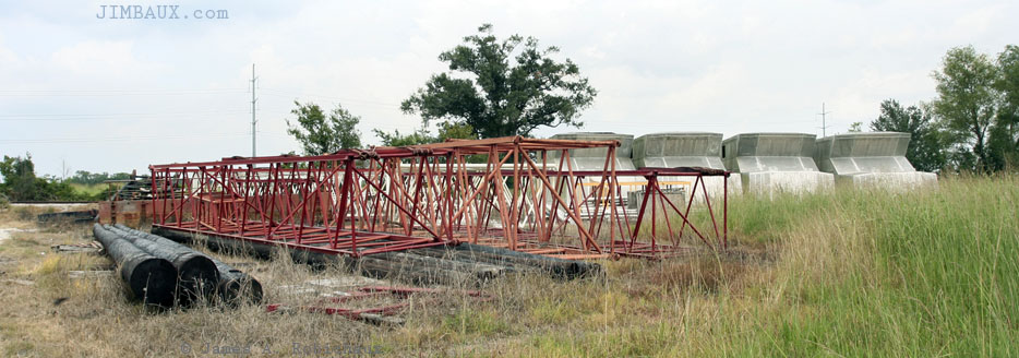
Gosh, why couldn’t this place have gotten plate steel delivered by rail? The branch might still be operational today if it did.
Now, I could either say that there will be no September 2009 Sampler essay, or I could say that this is the September 2009 Sampler essay, since I took the camera out only twice in September and both times were to photograph things that aren’t appropriate to share here – one a family gathering and the other something to do with the day job thing.
October had a similar issue, meaning that you’re not likely to see another sampler essay until November.
Epilogue
Deep down inside, below my consciousness, I felt that I had peaked in life. I was starting to work in what would be my last good year as a school teacher. I was still really good at it, but I felt like I had peaked at it, that I wasn’t going to get much better at it.
And I wanted so much more out of life.
And, soon, later that fall, I would for the first time meet someone who came into my life and whose presence resulted in my eviction from my home less than a decade later.
The following spring, someone would come into my life even more and flash a mirror back at me, forcing me to face some ugliness inside.
There is so much more, so much better, that I could be doing in this world, in this life, if only I were enabled to do it.
Jim